

Ultima Thule
-
Posts
923 -
Joined
Content Type
Forums
Store
Blogs
Downloads
Events
Gallery
Posts posted by Ultima Thule
-
-
2 – Is our plan overly aggressive? I don’t know yet where we are docking (Holland America is not on the port schedule yet, as best I can see)
Plans sounds ok to me. (I'll return to question 1 later)
3 – How do we identify which stop to get off at?
There are digital note boards in the buses and trams that show end stop name and next stop, alternating between Finnish and Swedish language.
4 – I believe you said we could buy our 24hr ticket from the driver – but we would prefer to use a ticket machine (to use our credit card). Do the machines have purchase instructions in English also? Are the ticket machines located at most stops? You also mention kiosks.....do the kiosks take credit cards....are they easily located around Market Square?
Ticket machines have English instructions but there are only a few of them, far apart. Kiosks do accept credit cards. This map shows the location for machines and sales points:
-
My experience was public restrooms in Helsinki were not free.
Since April 2015 public restrooms in Helsinki should be free of charge.
However, at the moment they are closed due to some dispute. The legality of the contract between the city and the cleaning company has been challenged by another cleaning company or something like that. Hopefully things have been sorted out before the tourist season starts.
-
This map perhaps clarifies things further.
https://www.openstreetmap.org/#map=17/59.33156/18.05828
Desdischado's map http://kartor.eniro.se/m/5xglV also shows the subway system (dotted lines) and T-Centralen station quite well. There are three concentrations of entrances marked with a "T", each corresponding to a ticket hall. Those near the Central Station leads to the red and green lines located above each other at a depth of 9 and 14 meters with the train platforms located under the "Klara Kyrka".
Those between the City Terminal and Näringsdepartementet (the Economy ministry) leads 30 meters down to the blue line with its train platform located where it says "Wallgren & Parteners" on this map. All three lines (red-green-blue) have a common east ticket hall at Sergels Torg (the grey area on the map). And there as also a connecting corridor with moving sidewalks between the blue and red/green train platforms (i.e between "Wallgren & Partners" and "Klara Kyrka" on the map) so one can change train without having to move up to the ticket hall and back down. So think of the whole system as the letter "A" turned sideways with the top pointing Northeast.
Also have a look at this you tube video, showing much of the subway and railway station:
-
Here are links to pdf files for all bus time tables with list of stop at the bottom. (sorry, I was unable to find an English link)
http://sl.se/sv/info/puffar/tidtabell/#/TimeTableSearch/GetLineTimeTables/Buss/NULL/NULL/BUS/35/0/10
.. and subway lines:
.. and tram lines:
... and while searching I also noticed there will be changes to several bus lines after midsummer! (in Swedish): "Förändringar i SL-trafiken" / "Nytt linjenät för innerstadsbussarna"
Map:
http://sl.se/contentassets/729d4a6ae7fc42db8cb8221f71367d65/oversikt-innerstan.pdf?id=943
Desdichado will probably be able to give you better details about that.
And regarding your Saturday trip from from the hotel to Old Town Desdichado's suggestion using bus 5#3 is probably the best as the bus stops near the hotel while it is a bit of a promenade to the T-central but I gave the subway info as well as it is always good to know the alternatives.
-
Saturday AM +PM
Arrival at hotel, check in, leave luggage and walk to Old Town
If taking tram, T-Centralen station, red line, one stop, get off at Gamla Stan ( is there a direction we should be aware off?)
I assume you mean the subway (T-bana) rather than tram.
From T-centralen to Gamla Stan (one stop) you can use either the red line on the upper level, direction Norsborg/Fruängen or the green line on the lower level , direction Hagsätra/Farstra Strand/Skarpnäck.
At Gamla Stan the red and green lines are on the same level, 4 tracks side by side at street level. To exit you need to go down the steps, cross the gates and then up again.
3/ Is there anywhere to eat a quick bite between the Vasa and Abba museums?
The Vasa museum has a lunch restaurant
4/ I saw a very good map of Stockholm bus route but I can't seem to find it, do you a link?
4/ Bus map:
http://sl.se/resources/maps/geographics/2015/7510.Innerstan.2015.html
-
Yes.
You can find storage lockers at Stockholm central station and at the adjacent Cityterminalen.
http://www.cityterminalen.com/Documents/Karta-november-2015.pdf
https://www.arlandaexpress.com/files/kartor/sthlm_orienteringskarta_k4.pdf
-
A very nice FAQ by Jonza.
Walking distance to Market Square: 3.5 km
Public transport: Tram 9 from West Terminal about 400 meters from the berth. There is a green line on the ground from the berth to the tram stop. See in Journey planner
HoHo: stops by the ship
Ship’s shuttle: Almost always offered
A little addition regarding berth LMA. Tram 6T might be an option for returning to the ship. Note that tram 6T is only replacing tram 6 in the afternoon, so you cannot use that option to get into town in the morning.
-
There is usually a different website for each city.
For example he preliminary 2016 list for Helsinki is now up at:
http://www.portofhelsinki.fi/passengers/expected_cruise_ships
-
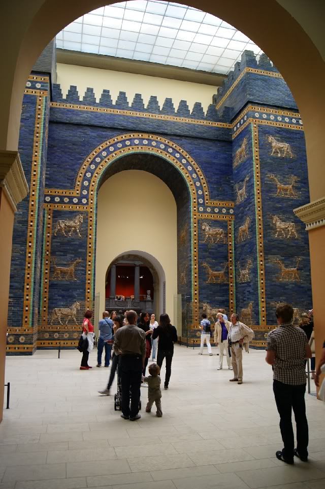
Pergamon Museum, Ishtar Gate (Babylon, 575 BC):
-
We are flying out of Tegal Airport, researched TXL Airport Shuttle and they want over $125.00 dollars to take us to the airport.
Are you joking? $125.00 dollars? Tegel airport just outside downtown. Its just five miles from Mitte to the airport as a bird flies and cannot be more than 7 miles by road! Just take a normal taxi!
Or if you wanna do it really cheap, take S-Bahn or Subway, either to Alexanderplatz and TXL JetExpress bus from there, or to Zoologisher Garten and take X9 JetExpressBus from there. Everything included in the local transport ticket (6.90 Euro = $7.50 per person for the whole day)
-
How far is the center of Stockholm to ARN?
37 km / 23 miles as a bird fly. A little bit longer along the roads of course.
-
If you take a virtual tour with google street view you can see that several souvenir shops in Västerlånggatan in Gamla Stan have Dala horses in their windows. For example in the block north of Storkyrkbrinken you can see them in the windows on both side of the street (Little Sweden & Old Town Souvenir Shop). I know the google street view pictures might be a few years old but still, I don't think there should be any problem finding them in some of the shops.
-
In Helsinki it will be at West Harbour but its too early to say if it will be on the west side of the bay, quay LMA (tram #9) or east side of the bay (a. k.a. Hernesaari) quay LHC (bus #14).
http://www.portofhelsinki.fi/passengers/international_cruise
(The link is just for the picture. Ignore what that web page says about bus 14B - old information).
-
Credit cards should work fine in Finland as well.
-
The most simple way is to use the local train (S-Bahn). The Munich airport is built like the letter "H" with Lufthansa using one side (terminal 2) , most other airlines the other side (terminal 1) and with the S-Bahn terminus in the middle (Airport center). Just use the moving walkways and follow the signs to the S-Bahn. There is a info point opposite the escalator down to the train, where you can buy a ticket if you don't want to use a ticket machine.
Its a rather long trip to town center (41 min) so a single ticket (Einzelfahrkarte - Gesamtnetz) will cost you 10.80 Euro. If you want to use stripe cards (Streifenkarte, sold 10 for 13 Euro), its 4 zones for a total of 8 stripes per person = 10.40 Euro. If you are three or more (or even just two if you also want to use public transport later that day) I highly recommend buying a group day ticket for the whole net (Gruppentageskarte - Gesamtnetz) for 22.30 Euro which gives 5 adults ( kids 6-14 equals 1/2 adult so for example 3 adults + 4 kids can use a single ticket) access to the extensive S-Bahn, Subway (U-bahn), tram and bus net for the whole day.
Use S-8 to get into the city (Hauptbahnhof). The airport is the terminus so you cannot go the wrong way. S-1 will also take you to the city but will take a slightly longer way.
Also, when buying a ticket, double check if it should be validated in a machine or not. A few months ago I bought a day ticket in a ticket machine at Haubtbahnhof only to find out it was too wide for the slot to be validated. So I had to ask at the info point to be sure that ticket did not had to be validated (regardless what the MVV website said).
Also see:
http://www.mvv-muenchen.de/en/homepage/index.html
http://www.munich-airport.de/en/consumer/anab/bahn/index.jsp
-
For Helsinki it will most probably be West Harbour (a former container port) either at quay LHB, LHC or LMA.
While there are no technical problems to walk its a rather long way into town so most take a shuttle bus. Then Helsinki is easy to do yourself.
-
Train S8 will take you straight from the airport terminal to Marienplatz. Train S1 will also take you to Marienplatz but will take another route and take a little bit longer as it will stop and connect to another train set during the way.
-
it's about a 45-minute walk from your boat to Gamla StanI seem to remember it taking maybe in the range of 20 minutes.
I have walked the route between the Viking line ferry terminal and Slussen several times and I know it takes 20-21 minutes for me.
(The Viking line ferry terminal is at the quay next to S167 Stadsgarden, about a 1000 feet closer to the city.
Slussen is a kind of cloverleaf interchange that connects the bridges to Gamla Stan with the road net and also includes a bus terminal, a subway station and a local railway station.)
So adding a few minutes for the 1000 feet mentioned above and two minutes for the bridge from Slussen over to Gamla Stan to 20 minutes and I would suggest it takes "less than half a hour". The total route is almost exactly 2 km or 1 1/4 mile long.
-
I am looking at walking from the Vasa Museum to Sergels Torg.
1. Is there any reason not to make this walk (e.g. unsafe area of town, poor or non-existent footpaths, etc.)?
2. I see that the route goes along Strangvagen. Is this a scenic walk?
Its a very nice and easy walk, especially if the weather is sunny. I have done that one myself several times. I think Standvägen has the highest housing prices in Sweden so its a wealthy district.
You will then follow Hamngatan cross the city center. First you'll see the Royal Dramatic Theatre with its golden entrance, then passing Norrmalmstorg square, "Kungsträdgården" - the King's Garden park, the pretigious "N.K." Department store and the entrance to the "Gallerian" shopping mall before reaching "Sergels Torg".
-
Do you think I could find ammonium chloride in a grocery store and legally bring it back with me for personal use?
Sorry to make you disappointed but I don't think you'll find any pure ammonium chloride in a grocery store. At least I have never seen any. Possibly a pharmacy might have it?
-
Tallinn maritime museum:
http://www.lennusadam.eu/en/visit-the-museum
Part of the museum is in "Fat Margaret tower"", part at the Seaplane Harbour.
-
For Helsinki try:
Café Ekberg
Bulevardi 9, next to the #3 tram stop, some 2 1/2 blocks from where the shuttle buses use to stop.
Karl Fazer Café
Kluuvikatu 3, half a block north of the Esplanade park.
For sweets I commend you try Karl Fazer (pronunced "fat sir") chocolate, especially Fazer blue milk chocolate bar.
Also popular among tourists are Fazermint and Dumle (the latter was originally a Swedish candy, now produced by Fazer).
See:
http://www.fazer.com/our-brands/
in Finland you should pick up some Finnish liquorice, no idea where to buy it though.A little warning about Finnish licorice. Apart from "normal" licorice there is something called salty liquorice, that is flavoured with ammonium chloride. Known in Scandinavia as salmiak or salmiakki its an acquired taste. I love it myself but people not familiar with ammonium chloride might find the taste weird or even horrible. (You can search for "salmiakki" on Youtube for reactions.)
-
We are looking at switching to the ferry instead of the water bus. When looking at the map it appears the water bus lets us off at Kings Gate on the southern end of the island and the ferry drops and picks up at the northern end of the island. Does it make sense to take the water bus down and then walk the island up north to take the ferry back?
Looks like the water bus costs 4.50 e single trip and 7.00 return so the difference is not that much to the ferry costs 3.00e / 5.00 e. So just try to find a combination that fits your time table.
-
Which HOHO buses come the most frequently? Best routes? What would you recommend?
There is a green and a red line. I think both are much alike and with about the same bus frequency.
green line:
http://www.stromma.fi/en/helsinki/sightseeing/sightseeing-by-bus/hop-on-hop-off/
red line:
Helsinki 2016 advice thread and FAQ
in Northern Europe & Baltic Sea
Posted · Edited by Ultima Thule
As Jonza said, the Market Square including the old Market Hall is the most tourist oriented while the Hakaniemi Market is more for the locals. The Hakaniemi hall is bigger than the other ones with two floors (food at the ground floor and other stuff on the upper floor). However note that the Hakaniemi hall will close sometimes in August 2016 for a two year repair!
These pictures showing the merchants might give some idea what to find at Hakaniemi hall even when the text is in Finnish only. http://www.hakaniemenkauppahalli.fi/kauppiaat/
The Hietalahti hall might be the least interesting of the trio but on sunny summer days, especially on weekends the flea market outside might be interesting.
Regarding the ship, are we perhaps talking about "Princendam" 11 June / 29 July ? Then it is Katajanokka (#5 on the map): http://www.portofhelsinki.fi/matkustajille/kansainvaliset_risteilyalukset