

Ultima Thule
-
Posts
923 -
Joined
Content Type
Forums
Store
Blogs
Downloads
Events
Gallery
Posts posted by Ultima Thule
-
-
Hello: We dock in Helsinki at 7:00 am. Is the market --or anywhere else--open at that time? Thanks.
Market opens at 6:30 Mon-Sat and during summer also Sunday 10:00
-
Thanks in advance. In the planning stage for Helsinki visit. Do you know the approx distance from the Helsinki Central Train Station to the Design area? Is it a short walk (10-15 minutes) or do we need a tram or bus? If public transportation where located? Bus/Tram# Cost? Do we need to purchase a special transportation card or token?
Many thanks
Carole
If this is what you mean
http://www.designdistrict.fi/map
then it starts just a few blocks south of the railway station.
-
I noticed on their website that you provided (thank you for that) the tours are only for 10 people at a time.
I think that's a misunderstanding. Reading the Swedish text it is clear that they want to say that the guided tours are meant for individual tourists and that they therefore ask groups of 10 persons or more to make special arrangements so that huge groups will not fill up places in the normal tours meant for individual tourists. So the tours themselves are not limited to 10 persons. Rather, they ask you not to come and ask for 10 tickets.
But I have some idea that there might be a limit (10?) on the special tower tour? (Its not in the text as the tower is closed right now).
It also says that tickets cannot be bought or booked in advance.
-
edit what is wrong with the pictures?
I think there is max of four (or five?) pictures per post and that might be the reason. Either try to resend with just four pictures or send just the links to the pictures.
-
Our ship will dock at Vartahamnen 523 on June 27th. What is the best way to get to the Vasa from here?
Not sure about the exact location of the Värtahamnen 523 but it should be somewhere between Siljateminalen and Frihamsterminalen on this map (scroll map up and to the right):
http://sl.se/scripts/kartor-geografiska/7510.Innerstan.2011.html
Bus 76 seems to be the best one. Don't know the name of stop closest to Värtahamnen 523 but going to Vasa you should get off at stop "Djurgårdsbron".
Here is the bus 76 winter table. At the bottom of the table there is a list of all bus stops (hållplatser in Swedish).
-
from Suomenlinna you can see a little island with a lighthouse. The ferries were passing that island when I made it to a view point near the cannons (before King's Gate) a little before 10. Would you happen to know what island or lighthouse that is? I'm a big lighthouse nut and went crazy in the Baltic seeing so many lighthouses and aids to navigation! Whew!
Harmaja if the most known one and might be the one you are thinking of
http://en.wikipedia.org/wiki/Harmaja
but zoom in on this map yourself:
http://map.openseamap.org/map/?zoom=12&lat=60.13528&lon=24.98437&layers=BFTFFFFFFFF0FF
-
Hi Sinny
You said to take tram 3 from Kampii and Uktima Thule says 3B from one or two places?
Help please! Which is better?
There is no tram "3", its either called "3B" or "3T". Its the same tram but it will change name twice during the route. The only time you have to worry of the name is if you get on it at the stop in front of the railway station. In that case you have to remember that tram 3B will turn left and tram 3T will turn right. Otherwise you can ignore the letter.
-
We are arriving at Hernesaaren in Sept. My first stop will be for the island. I take bus #14 and get off???
As I said in post #223 there is no easy way to get to the market by bus any more.
After walking around the island, we want to go to the Rock Church. Is it walkable from the ferry or do we take the bus? And if bus, which one?
Its 1.2 miles easy walk through downtown. If you don't want to walk you should take tram 3T. Be sure it goes in right direction, (i.e towards the cathedral, not the one going south following the harbour.). Get off at stop "Kauppakorkeakoulut", that should be the seventh stop after the market.
Walk back half a block and turn left and go uphill.
At the end of the day which is the best way to get back to the port?
Bus 14 will take you from the Rock Church region straight back to the ship. Just walk back to where you got off the tram ("Kauppakorkeakoulut") and take the bus in the opposite direction (i.e. going east)
-
Hi,
Is this true that bus 16 is suspended from 13th August?
Yes
If so will I need to get bus 14 and change to bus 17 or tram 3B/3T?
Can I walk from bus 14 stop to the market square if so do you know how far it is?
Here is new route map and stop list for bus 14.
You could change from bus 14 to tram 3B quite soon after exiting the harbour , the stop name is "tehtaanpuisto" (next to the Michael Agricola church with its high tower.) You'll find tram 3B stops for both directions a little bit forward. You should use the tram stop on the same side as the Eira Hospital (beautiful old yellow Art Neveau type building) to get to the market
Or you can step off the #14 bus at stop "Bulevardi", walk back half a block, turn left and walk along the Boulevard and the Esplanade to the market.
Distance is almost exactly 1 km (0.63 miles), very nice and easy walk.
-
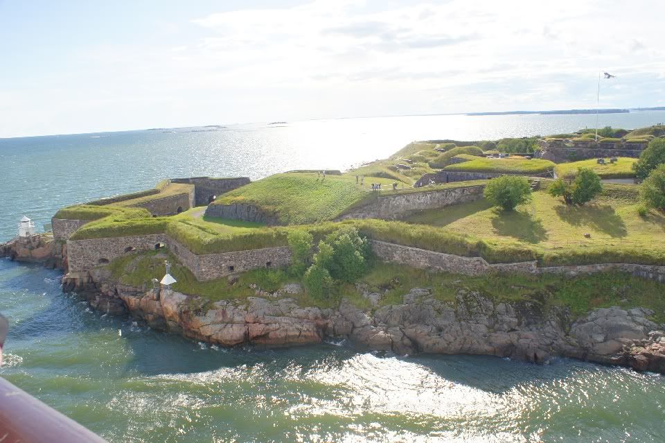
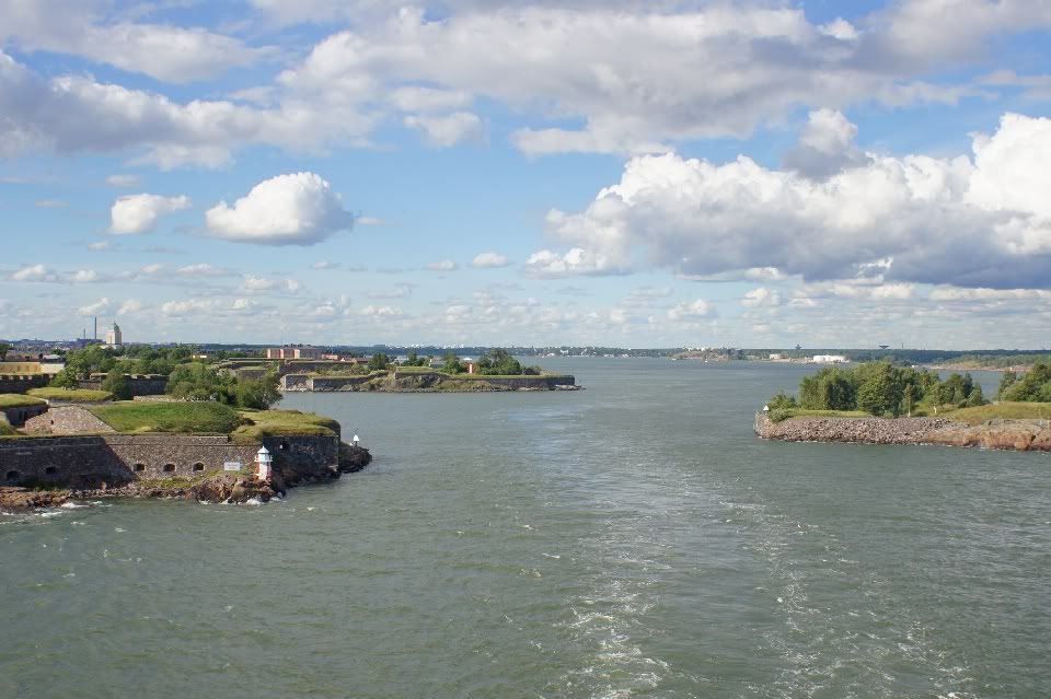
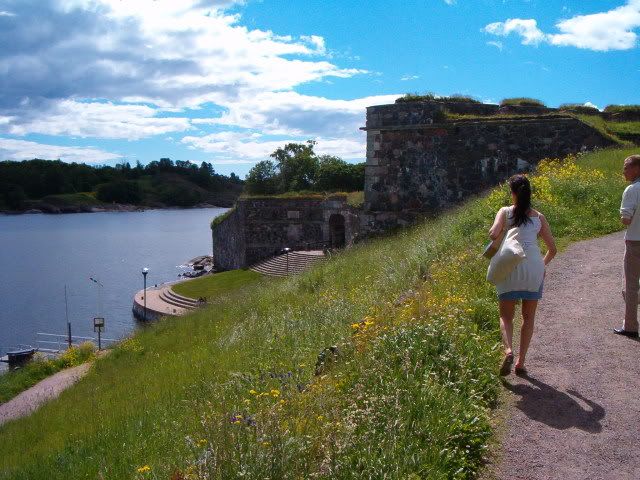
Do the ferries really come as close as that picture implies, or is there some kind of photographical magic going on? I just don't understand why they have to get so close to land. Also, if I wanted to see them, where would be a good vantage point?
The first two pictures are taken from same ship you see on Sinppu's picture.
As you can see on these pictures the only way past the fortress deep enough for ships that size is very narrow indeed. The Stockholm ferries going through there twice daily are 581 and 666 feet long.
The largest ship ever going through the strait was 853 feet Orainia (II) as an experiment but ther pilot sad "never again".
The third picture shows what in my mind is a good viewing point, on the east side of the southern island, on the hill north of the "Kings Gate"
-
Sadly I have to report that from 13 August onwards there will be major changes to Helsinki tram and bus routes. Some of the changes to the bus routes are completely idiotic and are executed against strong protests from the locals. (Guess the planner is the same "genius" that messed up tram 3B/3T a few years ago so that the trams nowadays change name twice during the route.)
Devastating for the cruise passengers is the fact that bus 16 will no longer run between West Harbour and the Market. Bus 14B will be renamed bus 14 and still serve the West Harbour, quays LHC and LHB. But unlike former bus 16 its not that obvious where to exit or enter bus 14 in downtown.
Here is a map of the downtown bus lines after 13 August (with red indicating deleted routes):
http://www.hsl.fi/FI/aikataulutjareitit/Documents/Muutokset_syksy_2012/HKI_14_17_18_24.pdf
Tram 9 will now serve the west side of West Harbour (i.e the side where quay LMA is), replacing buses 15A and 15v.
http://www.hsl.fi/FI/aikataulutjareitit/Documents/Muutokset_syksy_2012/HKI_9.pdf
(I'm sorry that I have not mentioned this before but I had had some hope the changes would be delayed until the tourist season was over.)
-
I was wondering where you find the 3 Tram once you are at the Central Railway Station.
Tram stop platforms are right outside Railway Station main entrance.
-
After doing a little research (unfortunately without a subway map in front of me!) I'm still a bit confused on the Kungstradgarden station. Is it closed completely, with no trains running through it, and nobody allowed to enter it? That's what I assumed, but from the above, I'm wondering if any trains go through the station without stopping that would offer a glimpse of the art work.
Unfortunately Kungsträdgården is a terminus station. The part of the line going on to Vasa and Skansen was never built.
See
http://en.wikipedia.org/wiki/File:Stockholm_metrosystem_map.svg
-
How does one get from Stadsgarden Port to the National Museum of Antiquities?
Taking the subway from Slussen to Karlaplan (red line towards Ropsten) is what first comes to my mind.
-
Thank you, both, Ultima and Sinppu, for your help to all of us! I've been lurking on this thread and have learned quite a bit from it.
We will be in Helsinki on Sunday, June 17th, docking at Hernesaari. One question that I don't think has been asked yet, is how frequent is the transit service (Bus 16 and tram 3B/3T) on Sundays? Here at home, we have reduced frequency for our transit system on Saturdays and Sundays, so am concerned that we need to take this into consideraton to ensure we get back to the ship in time.
Thank you!
Indeed a good question. Yes, summer is less frequent than winter and weekends also have reduced frequency.
I don't have access to this year's Summer time table yet but here are the summer 2011 time tables for bus 16 & tram 3T:
http://aikataulut.hsl.fi/kesa/linjat/en/h16.html
-
I looked up the web site that was on this thread for where the ships are docked and ours is at Kanavaterminaali. I then looked at the map but could not find it. Does anybody know how to get to Market Square from there. Thanks
Its located in Southern Harbour on point Katajanokka at the end of the bay and straight under the Uspenski Cathedral. Perhaps the best location of all quays! You'll be able to look down on the Market Square from the ship deck and its less than 1/4 mile walk to it.
http://maps.google.com/maps?hl=sv&ll=60.166899,24.959151&spn=0.002399,0.00544&t=h&z=18
-
Sign over escalator should say "Kaukoliikenne" or something similar.
To be exact, it says:
Kaukoliikennelaiturit 1-35
Plattformar för fjärrtrafiken 1-35
-
We are on the Emerald Princess and will be in Helsinki on June 1. The ship is in port from 7 AM until 4 PM. Can we get to Porvoo on our own and back during that time frame, and how would we do it.
Short instructions:
From West Harbour take bus 14B. Exit at stop "Kamppi". Enter red brick bulding where it says "KAMPPI Linja-autoasema/Busstation" . Down the steps. Turn around , down the escalator. Turn around again. Follow the metropolitan bus platforms from 57 down to 40. Then keep to the left. Locate the subway (Metro) station entrance - half tube made of yellow brick scales like a lizard. Down the escalator OPPOSITE the subway entrance. Sign over escalator should say "Kaukoliikenne" or something similar. Buses to Porvoo starts from platforms 1-4. A table to the right of the platforms shows the bus times and correct platform. You can enter the platforms through the glass doors when the red cross turns to green. Tickets from the bus driver cost somewhere between 10 and 15 Euro.
Trip time is about 1h5min and there is no problem knowing where to get off. Buses back to Helsinki will stand in line in front of the Porvoo bus station building. Check the times on the table outside the building. They should be several buses each hour.
Here is a picture of the subway entrance:
http://fi.wikipedia.org/wiki/Tiedosto:Kampin_terminaali,_gekko1.jpg
-
So how can we go from the "Hernesaari"-port with the public transport (which one(s)??) to the city and do from there (where?) the "must-have-done" sightseeing-places (3B/3T) ??
Where at the "Hernesaari"-port can we buy the day-ticket for € 7,-?
Are the tickets-offices or in the bus/tram/ferry?
You should be able to buy the one day ticket from the bus driver.
Bus 16 takes you from the port straight to the Market Square (get off at stop:" Kauppatori"). You'll be in the town center near the catedrals and 3T tram stop is across the street- But you could also get off much earlier at stop "Eiraan sairaala" where the bus and 3B tram meets.
Bus 14B is an alternative. Stops named "Iso Roobertinkatu", "Bulevardi" (go back half a block), "Kamppi" and "Kauppakorkeakoulut" should be near a 3B or 3T tramstop.
-
We will be on the Eclipse arriving on 26 July. I think we will be docking in the West Harbor. Is it too far to walk from the West Harbor to the center of town or should we ride a bus or tram? If so what is number bus or tran do we need to take? If we visit Suominlinna last in the afternoon what tram or bus will get us back to the ship? Thanks for all your help.
In this case it is West Harbor Melkki Quay (LMA), #4 on this map:
http://www.portofhelsinki.fi/passengers/international_cruise
Distance is about a mile through the harbour area plus another mile through the city to the center.
Its up to you if it is too far but in my mind it is quite hard to find your way in the harbor area at the moment with lots of rebuilding and redirecting of the walkways going on. The only decent bus option would be 15A to the railway station but its a bit of walking from the quay to the bus stop.
Only other options are buses 15 or 15v or tram 8 to nearest subway station (Ruoholahti) and then taking the subway to the railway station but in that case you'll have to know exactly what you are doing. Also, neither bus nor tram stops are really near the quay.
So in this case I really recommend taking a shuttle bus into downtown even if it might cost a bit more.
-
4. Is it possible just to enjoy the scenery going to Suommelina and come back without going in? Just to save time?
Should not be any problem. In worst case if ferry crew insists that the ferry should be emptied, all you need to do is to turn around on landing stage and follow when new passengesr enters. The fortress islands are considered to be a city district with people living on them, so they are open, i.e you don't "go in" or pay entrance fee. Ferry ticket system is self service, i.e no control in normal cases. Its up to you to have a valid ticket in case of a spot check
-Sibelius Monument
regarding how to reach the monument from tram 3T see following threads:
post #10 at:
http://boards.cruisecritic.com/showthread.php?t=756666
post #30 at
-
1. Just to confirm with you that the name of the bus stops as follow: Hernesaari LHB is Hernesaaren laituri and Market square is Kauppatori.
Market square is Kauppatori, ok.
Hernesaaren laituri is the stop for for quay LHC. The stop for quay LHB is named Matalasalmenkuja-
3. I would like to go to Hietalahti Flea market.. is it walkable from Market square?
Note that the flea market is at its best only on sunny summer weekends.
0.9 miles easy walk from the Market square along the Esplanade and then the Boulevard. You could do part of the trip in tram 6.
Also note its actually a bit shorter from quay LHB to the flea market, some 0.8 miles.
6. I am using tram 3T going for one direction .. will be glad if you can let me know what is the sequence of the following attraction and their stops:
- senate square
-Suommenlina Fortress (By ferry from Market square)
- Temppeliaokio Church (Sammonkatu stop)
- Hietalahti Flea Market (Kauppatori)
-Helsinki Cathderal
-Sibelius Monument
Olympic Stadium (may be tram pass by is enough!)
Ok consider you are taking the tram that makes the bottom part of the "8" in anti-clockwise direction. At bottom of the "8" it will change name from 3B to 3T. Then the order will be:
1 Market square - stop "Kauppatori"
2 Senate square & Helsinki Cathedral - stop "Senaatintori"
3 Temppeliaukio Church stop "Kauppakorkeakoulut" or "Sammonkatu"
4 Olympic Stadium - stop "Ooppera" ( a bit away but visible)
5 Sibelius Monument stop "Töölön Halli" (a bit away from the tram. It has been discussed here a long time ago. I'll try to find the link)
- Tram 3 will not go near the flea market. Use tram 6 for that.
stop list is found here:
-
Do you know the closest walking location of the 3T Tram stop from Hernesaari LHC?
Tram stop near Eira Hospital (search maps for "Eiran sairaala"), 1.35 Miles walk from LHC I'm afraid. That tram is not the best way to get from ship to downtown but once in downtown you'll have no problem to find a tram 3B/3T stop.
-
WE will be in Helsinki 26 July from 10:00-6:00 was wondering if there was a travel card that we could purchase that would cover all the trams, buses and metro and the ferry to Soumenlinna? If so do you happen to know the cost of the card? Where would we purchase one?
You can buy a 1-day ticket on the bus. Cost is 7 Euro (3.50 Euro for children)
http://www.hsl.fi/EN/ticketsandfares/singleticketsanddaytickets/Pages/17daytickets.aspx
Helsinki Questions? Glad to help!
in Northern Europe & Baltic Sea
Posted · Edited by Ultima Thule
Open hours:
according to activities: listen to the bulletin tel. +358 (0)9 2340 5940.
http://www.helsinginkirkot.fi/en/churches/temppeliaukion-church